


Urban archaeology in Gdansk
If you like maps, fire up your favorite geolocation tool and follow along as Isaak Wohlgemuth would have gone from home to work on a typical day in, say, 1908.
Put in a start location of Dobra 1A, Gdansk, Poland, the current address of Isaak’s former residence, where he lived with his wife Betty and their two daughters. The older girl is my grandmother, Elly Wohlgemuth Ringel, who is six years old as Isaak sets out on his walk.
For the destination put in Zabi Kruk 11 in Gdansk. That’s my best guess for where the Wohlgemuth moving business was located, probably with a warehouse and stables. Ask for walking directions and look at the route in 3D satellite view so you get a feel for the terrain.
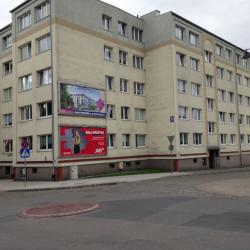
The first discovery is a disappointment. The building at Dobra 1–Abegg Gasse 1 in Isaak’s time–has been replaced with a particularly undistinguished postwar apartment building. The pictures show the current building and a nearby building from the period.
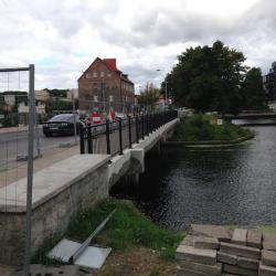
Go across the first bridge and proceed along ul. Torunska (it was Thornscher Weg to Isaak). On your left is a big fenced off swampy vacant field. The photo gives a picture of the scene. Beyond the field is a view of the southern ramparts of the old city.
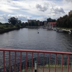
On the north side of the street alongside the canal is a major redevelopment project that looks like mixed use commercial and residential. There is a lot of new construction in and around Gdansk, but mostly it hasn’t yet touched this lower district of the old city.
Cross the island on Torunska and try to imagine what it was like in Isaac’s day. But so far there is not much to go on. Proceed across the second bridge, past the luxury Almond Hotel and on to the corner of Zabi Kruk.
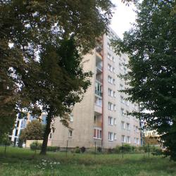
In Isaak's day this street was called Poggenpfuhl, and we are looking for Poggenpfuhl 73. But the numbers on Zabi Kruk are entirely different, reaching no higher than number 20 on the south end of the street on a block is that is now dominated by three high-rise Soviet-era apartment buildings.
You will check those out later, but for now you cross the street and go north on Zabi Kruk towards the big cathedral up ahead. This turns out to be the Church of St. Peter and Paul and it goes back to the 15th century. In front of the church is a historic information display that you stop to admire.
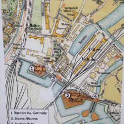
The multimedia exhibit of photos and Polish text covers not the church specifically but the history of this part of the city, the Alte Vorstadt. On one of the panels describing the southern fortifications and the city’s Lower Gate, your eye is drawn to the finely drawn map.
It is a detail of an 1840 map of the Alte Vorstadt showing all the key buildings and fortifications. That vacant field you noticed on the way over is shown on the map as the location of the "Güterbahnhof"—literally, a train station for goods, or freight depot.
Ah, this makes sense! It explains why the Wohlgemuth shipping company was located in this section of town, remote from current-day transport hubs.
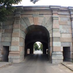
With that insight, you can now return to the south end of Zabi Kruk, where those high rises have replaced the business block where the Wohlgemuth company was established. You go by the present-day boating concession on the channel, explore around the surviving buildings adjacent to the old rail yard, and come out at the lower gate to the city, called today the Brama Nizinna Tor once known as the Leege Thor.
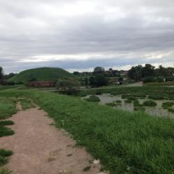
A former railroad right-of-way traverses a discrete opening in the surviving fortifications. Immediately above you is the imposing Żubr Bastion, one of 19 massive earthen mounds that surround the city. Zoom out on your mapping app to see the layout of the bastions. You will want to make your way up the trails to the top of the Żubr to enjoy the fantastic panorama.
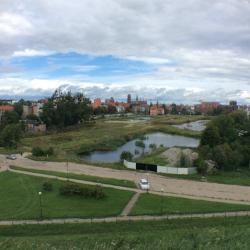
All of the sites called out on the 1840 map–the sluice gates, the Leege Thor, the Bahnhof, the approaches to the adjacent bastion–are all spread out below you.
Cell service is spotty up here, so you are having trouble learning a lot about the train station in real time. From the name and what little is known in family lore, you can infer it had been a freight shipping terminal serving the old Prussian territories. Maybe it had been bombed out in the war and never rebuilt.
The answers will come later when you can get back on line and spend some quality time with Google Translate. For now, enjoy the view and the pleasure of having discovered a little bit of history along the route of an ancestor’s walk to work.