The Wohlgemuth mill was on a branch of the Hommel River
I had expected to find the Wohlgemuth's mill building near to the Elbing River that flows north-sourth on the west side of the city. Instead the address books placed them inland to the east of the center city.
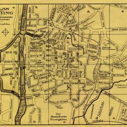
I looked for a period street map that might let me identify the location of Mühlendamm 8/9. The image above is from 1911 and gave just enough clues to point to the answer.
On the map, the street going down on a diagonal from the upper right is Outer Mühlendamm. Just past the intersection of Hohe Zinn Str., it changes to Inner Mühlendamm. Right around there on the map you see a small section of river, Die Hommel. The main part of Die Hommel nearby to the south. The small channel that runs by Mühlendamm must have connected to the main river in an underground culvert, and perhaps flowed at the other end under the city into the Elbing River.
Near as I could tell, our Wohlgemuth's mill must have been right at Mühlendamm where the Hommel comes to an apparent dead end. In the next post, I will quote a 1924 article about the Hommel, by then known by its Polish name Kumiela.