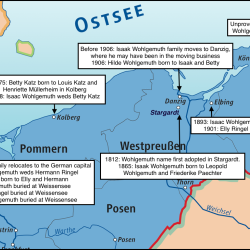
Wohlgemuth map, 1812-1942
I annotated this map of the northeastern section of the German Empire under Kaiser Wilhelm II between the years 1871 and 1918 with what we have learned about the Wohlgemuth family movements during that time period.
The map shows the provincial borders between East and West Prussia and neighboring Pomerania. I was wrong earlier when I said that Elbing was in East Prussia; it was within the boundaries of West Prussia. Also, Kolberg was in Pomerania, not West Prussia.

Display Download Link in Storyspace
No